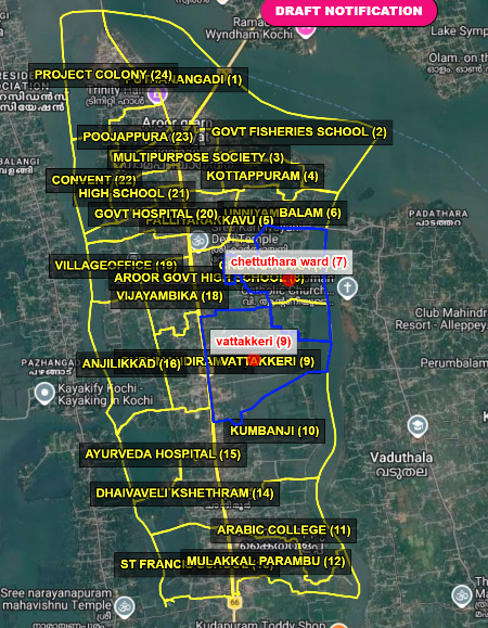
Map
Aroor Grama Panchayat consists of 24 wards:
1. Puthanangadi
2. Government Fisheries School
3. Multipurpose Ward
4. Kottappuram
5. Palliyarakkavu
6. Unniyambalam
7. Chettuthara
8. Aroor Government High School
9. Vattakkeri
10. Kumbanji
11. Arabic College
12. Mulakkal Parambu
13. St. Francis
14. Dhaivavili Temple
15. Ayurveda Hospital
16. Anjilikkad
17. Gurumandiram
18. Vijayambika
19. Village Office
20. Government Hospital
21. High School
22. Convent
23. Poojappura
24. Project Colony
Map Description Aroor Grama Panchayat is divided into 24 wards. The wards have been delineated based on the distribution of educational institutions, healthcare facilities, places of worship, fishing areas, and residential settlements across the Panchayat from north to south. The National Highway, coastal belt, backwater regions, and the influence of urbanization significantly shape the Panchayat’s development characteristics. Administrative and developmental activities of the Panchayat are implemented through ward-based development planning and governance mechanisms.